Parkwood night lights from space
Night Light of Parkwood (Washington) from space (United States) Src. Average luminocity for 10x10km area is 34.4872% and for 50x50km: 22.1264%.
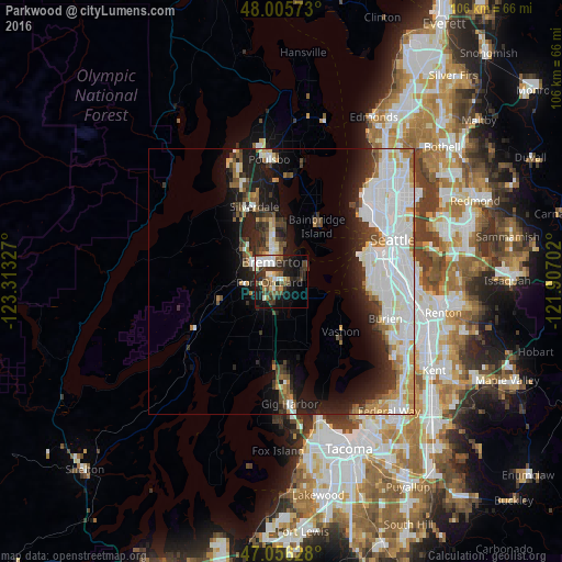
Analysis of Parkwood night lights 2016
Square area 10x10 km:
 5.26%
5.26%90-99
7.81%80-89
2.41%70-79
2.56%60-69
3.69%50-59
4.55%40-49
7.67%30-39
5.97%20-29
13.92%10-19
21.02%0-9
25.14%Square area 50x50 km:
7.1%90-99
5.27%80-89
1.7%70-79
1.79%60-69
1.92%50-59
1.75%40-49
2.14%30-39
2.43%20-29
4.79%10-19
9.23%0-9
61.89%Clear (daylight) street map image can be seen on geolist.org.
Map coordinates:
48° 0' 20.6" North, 123° 18' 47.8" West
47° 31' 59.3" North, 122° 36' 36.5" West
47° 3' 22.6" North, 121° 54' 25.3" West
Some cities around Parkwood sort by population:
• Bremerton
4.2 km =2.6 mi,  336°
336°
• Bainbridge Island
12.3 km =7.6 mi,  32°
32°
• Silverdale
13.9 km =8.6 mi,  332°
332°
• Port Orchard
2.1 km =1.3 mi,  292°
292°
• Vashon
14.8 km =9.2 mi,  130°
130°
• East Port Orchard
1.5 km =0.9 mi,  224°
224°
• Manchester
5.5 km =3.4 mi,  62°
62°
• Tracyton
9.1 km =5.7 mi, 338°
5806274 (p: 7,126)
Sources (retrieved 2019-11-25):
» Earth at Night: Flat Maps 2012, 2016