Tonawanda night lights from space
Night Light of Tonawanda (New York) from space (United States) Src. Average luminocity for 10x10km area is 74.1587% and for 50x50km: 36.4102%.
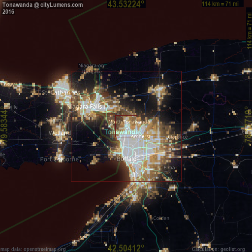
Analysis of Tonawanda night lights 2016
Square area 10x10 km:
 15.56%
90-99
22.06%80-89
10.79%70-79
11.75%60-69
10.63%50-59
10.32%40-49
6.03%30-39
11.9%20-29
0.95%10-19
0%0-9
0%Square area 50x50 km:
7.75%90-99
7.24%80-89
3.84%70-79
4.47%60-69
5.31%50-59
5.33%40-49
5.45%30-39
5.6%20-29
6.92%10-19
12.71%0-9
35.38%Clear (daylight) street map image can be seen on geolist.org.
Map coordinates:
43° 31' 56.1" North, 79° 35' 0.4" West
43° 1' 13.2" North, 78° 52' 49.1" West
42° 30' 14.8" North, 78° 10' 37.9" West
Some cities around Tonawanda sort by population:
• Buffalo
14.9 km =9.3 mi,  179°
179°
• Amherst
8 km =5 mi,  125°
125°
• North Tonawanda
2.4 km =1.5 mi,  32°
32°
• Grand Island
6.8 km =4.2 mi,  282°
282°
• Fort Erie, CA
14 km =8.7 mi,  197°
197°
• Kenmore
6.1 km =3.8 mi,  172°
172°
• Eggertsville
8.9 km =5.5 mi,  135°
135°
• Williamsville
13.2 km =8.2 mi,  118°
118°
5141175 (p: 14,907)
Sources (retrieved 2019-11-25):
» Earth at Night: Flat Maps 2012, 2016