Eggertsville night lights from space
Night Light of Eggertsville (New York) from space (United States) Src. Average luminocity for 10x10km area is 94.5222% and for 50x50km: 37.0544%.
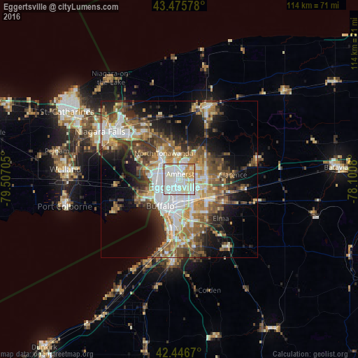
Analysis of Eggertsville night lights 2016
Square area 10x10 km:
 40.79%
90-99
37.94%80-89
11.59%70-79
8.1%60-69
1.59%50-59
0%40-49
0%30-39
0%20-29
0%10-19
0%0-9
0%Square area 50x50 km:
7.86%90-99
7.36%80-89
3.9%70-79
4.72%60-69
5.47%50-59
5.98%40-49
5.72%30-39
5.36%20-29
6.37%10-19
11.3%0-9
35.96%Clear (daylight) street map image can be seen on geolist.org.
Map coordinates:
43° 28' 32.8" North, 79° 30' 25.4" West
42° 57' 48.2" North, 78° 48' 14.1" West
42° 26' 48.1" North, 78° 6' 2.9" West
Some cities around Eggertsville sort by population:
• Buffalo
10.5 km =6.5 mi,  215°
215°
• Amherst
1.7 km =1.1 mi,  11°
11°
• Cheektowaga
7.8 km =4.8 mi,  149°
149°
• North Tonawanda
9.7 km =6 mi,  329°
329°
• Kenmore
5.4 km =3.4 mi,  272°
272°
• Tonawanda
8.9 km =5.5 mi,  315°
315°
• Harris Hill
10.3 km =6.4 mi,  89°
89°
• Williamsville
5.4 km =3.4 mi, 89°
5116303 (p: 15,019)
Sources (retrieved 2019-11-25):
» Earth at Night: Flat Maps 2012, 2016