Williamsville night lights from space
Night Light of Williamsville (New York) from space (United States) Src. Average luminocity for 10x10km area is 86.6524% and for 50x50km: 34.4624%.
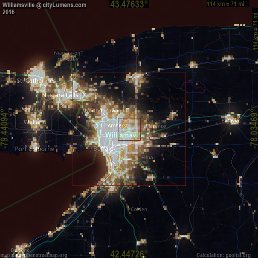
Analysis of Williamsville night lights 2016
Square area 10x10 km:
 23.81%
90-99
26.67%80-89
20%70-79
16.51%60-69
8.1%50-59
4.44%40-49
0.48%30-39
0%20-29
0%10-19
0%0-9
0%Square area 50x50 km:
7.38%90-99
6.82%80-89
3.59%70-79
4.25%60-69
4.98%50-59
5.55%40-49
5.5%30-39
5.04%20-29
5.93%10-19
10.71%0-9
40.25%Clear (daylight) street map image can be seen on geolist.org.
Map coordinates:
43° 28' 34.8" North, 79° 26' 27.4" West
42° 57' 50.2" North, 78° 44' 16.1" West
42° 26' 50.1" North, 78° 2' 4.9" West
Some cities around Williamsville sort by population:
• Amherst
5.3 km =3.3 mi,  287°
287°
• Cheektowaga
6.9 km =4.3 mi,  191°
191°
• Kenmore
10.8 km =6.7 mi,  271°
271°
• Depew
7.6 km =4.7 mi,  150°
150°
• Eggertsville
5.4 km =3.4 mi, 269°
• Tonawanda
13.2 km =8.2 mi,  298°
298°
• Lancaster
8.9 km =5.5 mi,  142°
142°
• Harris Hill
4.9 km =3 mi,  88°
88°
5144588 (p: 5,254)
Sources (retrieved 2019-11-25):
» Earth at Night: Flat Maps 2012, 2016