Kenmore night lights from space
Night Light of Kenmore (New York) from space (United States) Src. Average luminocity for 10x10km area is 92.3667% and for 50x50km: 38.436%.
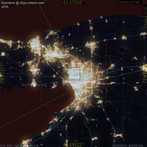
Analysis of Kenmore night lights 2016
Square area 10x10 km:
 48.57%
90-99
31.11%80-89
6.51%70-79
3.02%60-69
3.65%50-59
3.65%40-49
2.38%30-39
1.11%20-29
0%10-19
0%0-9
0%Square area 50x50 km:
8.1%90-99
7.7%80-89
4.05%70-79
4.84%60-69
5.75%50-59
6.03%40-49
6.06%30-39
5.8%20-29
6.95%10-19
11.87%0-9
32.85%Clear (daylight) street map image can be seen on geolist.org.
Map coordinates:
43° 28' 41.7" North, 79° 34' 23.4" West
42° 57' 57.2" North, 78° 52' 12.1" West
42° 26' 57.2" North, 78° 10' 0.9" West
Some cities around Kenmore sort by population:
• Buffalo
8.9 km =5.5 mi,  184°
184°
• Amherst
5.9 km =3.7 mi,  76°
76°
• North Tonawanda
8.1 km =5 mi,  3°
3°
• Grand Island
10.6 km =6.6 mi,  314°
314°
• Fort Erie, CA
8.9 km =5.5 mi,  214°
214°
• Eggertsville
5.4 km =3.4 mi,  92°
92°
• Tonawanda
6.1 km =3.8 mi,  352°
352°
• Williamsville
10.8 km =6.7 mi, 91°
5123247 (p: 15,160)
Sources (retrieved 2019-11-25):
» Earth at Night: Flat Maps 2012, 2016