Timonium night lights from space
Night Light of Timonium (Maryland) from space (United States) Src. Average luminocity for 10x10km area is 75.9762% and for 50x50km: 48.2607%.
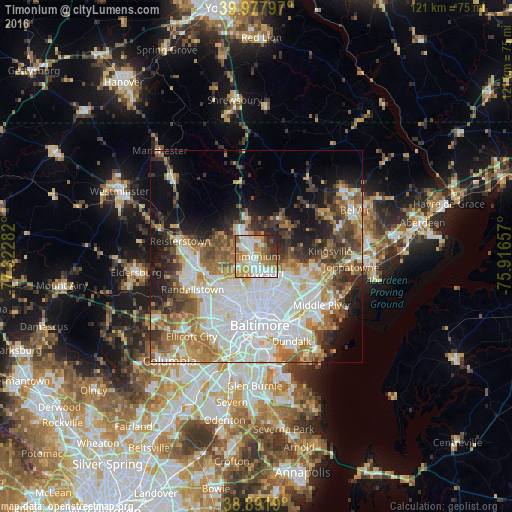
Analysis of Timonium night lights 2016
Square area 10x10 km:
 20.92%
90-99
19.22%80-89
6.12%70-79
16.5%60-69
14.29%50-59
8.33%40-49
4.25%30-39
4.59%20-29
5.61%10-19
0.17%0-9
0%Square area 50x50 km:
14.84%90-99
9.74%80-89
5.07%70-79
5.88%60-69
6.38%50-59
5.88%40-49
5.58%30-39
5.56%20-29
6.38%10-19
9.6%0-9
25.08%Clear (daylight) street map image can be seen on geolist.org.
Map coordinates:
39° 58' 40.7" North, 77° 19' 22.2" West
39° 26' 13.4" North, 76° 37' 10.9" West
38° 53' 30.8" North, 75° 54' 59.7" West
Some cities around Timonium sort by population:
• Towson
4.2 km =2.6 mi,  158°
158°
• Carney
9.5 km =5.9 mi,  119°
119°
• Hunt Valley
7.2 km =4.5 mi,  345°
345°
• Cockeysville
5.3 km =3.3 mi,  337°
337°
• Lutherville-Timonium
0.8 km =0.5 mi,  66°
66°
• Mays Chapel
2.6 km =1.6 mi,  260°
260°
• Lutherville
1.8 km =1.1 mi,  197°
197°
• Hampton
3.4 km =2.1 mi, 117°
4371420 (p: 9,925)
Sources (retrieved 2019-11-25):
» Earth at Night: Flat Maps 2012, 2016