Hampton night lights from space
Night Light of Hampton (Maryland) from space (United States) Src. Average luminocity for 10x10km area is 76.0476% and for 50x50km: 50.4685%.
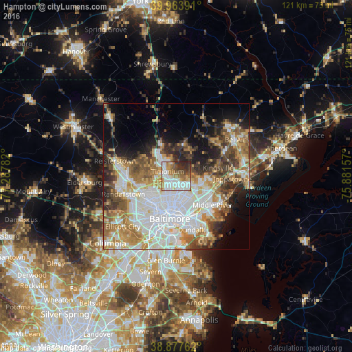
Analysis of Hampton night lights 2016
Square area 10x10 km:
 26.02%
90-99
20.58%80-89
6.63%70-79
8.16%60-69
12.24%50-59
6.46%40-49
5.61%30-39
7.48%20-29
6.8%10-19
0%0-9
0%Square area 50x50 km:
15.54%90-99
10.61%80-89
5.54%70-79
6.47%60-69
6.53%50-59
6.17%40-49
5.51%30-39
5.24%20-29
6.34%10-19
8.29%0-9
23.77%Clear (daylight) street map image can be seen on geolist.org.
Map coordinates:
39° 57' 50.1" North, 77° 17' 16.2" West
39° 25' 22.4" North, 76° 35' 4.9" West
38° 52' 39.4" North, 75° 52' 53.7" West
Some cities around Hampton sort by population:
• Towson
2.8 km =1.7 mi,  211°
211°
• Parkville
6.4 km =4 mi,  142°
142°
• Carney
6.1 km =3.8 mi,  121°
121°
• Cockeysville
8.2 km =5.1 mi,  321°
321°
• Lutherville-Timonium
3 km =1.9 mi,  310°
310°
• Mays Chapel
5.7 km =3.5 mi,  281°
281°
• Timonium
3.4 km =2.1 mi,  297°
297°
• Lutherville
3.6 km =2.2 mi,  267°
267°
4357289 (p: 5,052)
Sources (retrieved 2019-11-25):
» Earth at Night: Flat Maps 2012, 2016