Lutherville-Timonium night lights from space
Night Light of Lutherville-Timonium (Maryland) from space (United States) Src. Average luminocity for 10x10km area is 74.3963% and for 50x50km: 48.3467%.
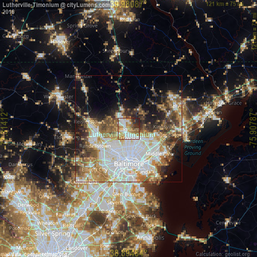
Analysis of Lutherville-Timonium night lights 2016
Square area 10x10 km:
 21.26%
90-99
18.88%80-89
5.78%70-79
15.14%60-69
13.44%50-59
6.46%40-49
5.27%30-39
4.93%20-29
8.33%10-19
0.51%0-9
0%Square area 50x50 km:
14.89%90-99
9.79%80-89
5.14%70-79
5.96%60-69
6.38%50-59
5.87%40-49
5.55%30-39
5.47%20-29
6.35%10-19
9.24%0-9
25.37%Clear (daylight) street map image can be seen on geolist.org.
Map coordinates:
39° 58' 51.1" North, 77° 18' 50.8" West
39° 26' 23.9" North, 76° 36' 39.6" West
38° 53' 41.4" North, 75° 54' 28.3" West
Some cities around Lutherville-Timonium sort by population:
• Towson
4.3 km =2.7 mi,  169°
169°
• Parkville
9.3 km =5.8 mi,  138°
138°
• Carney
9.1 km =5.7 mi,  124°
124°
• Hunt Valley
7.1 km =4.4 mi,  338°
338°
• Cockeysville
5.4 km =3.4 mi,  328°
328°
• Mays Chapel
3.4 km =2.1 mi,  257°
257°
• Timonium
0.8 km =0.5 mi,  246°
246°
• Hampton
3 km =1.9 mi,  130°
130°
7258897 (p: 15,814)
Sources (retrieved 2019-11-25):
» Earth at Night: Flat Maps 2012, 2016