Lutherville night lights from space
Night Light of Lutherville (Maryland) from space (United States) Src. Average luminocity for 10x10km area is 81.5578% and for 50x50km: 50.3526%.
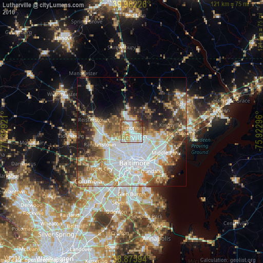
Analysis of Lutherville night lights 2016
Square area 10x10 km:
 24.32%
90-99
21.6%80-89
7.99%70-79
19.39%60-69
14.97%50-59
5.95%40-49
1.53%30-39
3.4%20-29
0.85%10-19
0%0-9
0%Square area 50x50 km:
15.41%90-99
10.55%80-89
5.19%70-79
6.25%60-69
6.45%50-59
5.99%40-49
5.72%30-39
5.97%20-29
6.47%10-19
9.98%0-9
22.01%Clear (daylight) street map image can be seen on geolist.org.
Map coordinates:
39° 57' 44.1" North, 77° 19' 45.2" West
39° 25' 16.4" North, 76° 37' 33.9" West
38° 52' 33.4" North, 75° 55' 22.7" West
Some cities around Lutherville sort by population:
• Towson
3 km =1.9 mi,  136°
136°
• Parkville
8.9 km =5.5 mi,  123°
123°
• Carney
9.3 km =5.8 mi,  108°
108°
• Hunt Valley
8.8 km =5.5 mi,  351°
351°
• Cockeysville
6.8 km =4.2 mi, 347°
• Mays Chapel
2.4 km =1.5 mi,  303°
303°
• Timonium
1.8 km =1.1 mi,  17°
17°
• Hampton
3.6 km =2.2 mi,  87°
87°
4361379 (p: 6,504)
Sources (retrieved 2019-11-25):
» Earth at Night: Flat Maps 2012, 2016