Timber Pines night lights from space
Night Light of Timber Pines (Florida) from space (United States) Src. Average luminocity for 10x10km area is 63.0813% and for 50x50km: 24.7072%.
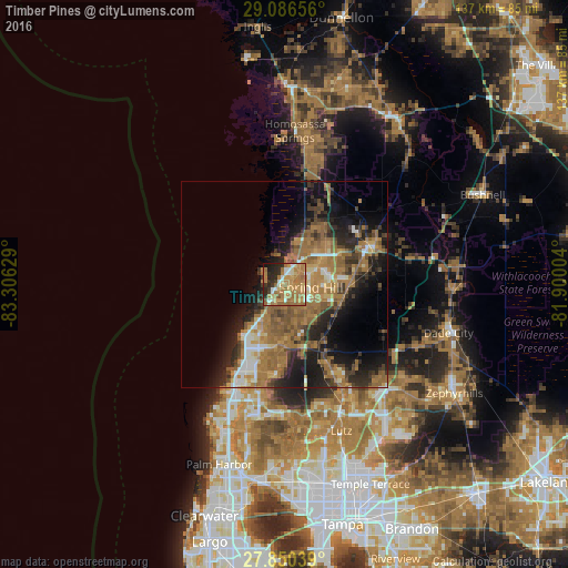
Analysis of Timber Pines night lights 2016
Square area 10x10 km:
 4.76%
4.76%90-99
7.74%80-89
7.14%70-79
18.25%60-69
36.31%50-59
3.57%40-49
0.79%30-39
4.76%20-29
13.29%10-19
3.37%0-9
0%Square area 50x50 km:
1.77%90-99
2.42%80-89
1.93%70-79
3.38%60-69
10.91%50-59
5.05%40-49
3.26%30-39
4.03%20-29
6.45%10-19
11.39%0-9
49.41%Clear (daylight) street map image can be seen on geolist.org.
Map coordinates:
29° 5' 11.6" North, 83° 18' 22.6" West
28° 28' 13" North, 82° 36' 11.4" West
27° 51' 1.4" North, 81° 54' 0.1" West
Some cities around Timber Pines sort by population:
• Spring Hill
7.6 km =4.7 mi,  84°
84°
• Bayonet Point
17.8 km =11.1 mi,  206°
206°
• Jasmine Estates
21.5 km =13.4 mi,  203°
203°
• Hudson
14.7 km =9.1 mi,  216°
216°
• Shady Hills
8.9 km =5.5 mi,  138°
138°
• New Port Richey East
24.9 km =15.5 mi, 200°
• North Weeki Wachee
9.9 km =6.2 mi,  25°
25°
• Brooksville
22.9 km =14.2 mi,  65°
65°
4175391 (p: 5,386)
Sources (retrieved 2019-11-25):
» Earth at Night: Flat Maps 2012, 2016