North Weeki Wachee night lights from space
Night Light of North Weeki Wachee (Florida) from space (United States) Src. Average luminocity for 10x10km area is 52.2973% and for 50x50km: 20.1727%.
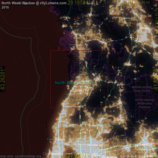
Analysis of North Weeki Wachee night lights 2016
Square area 10x10 km:
 3.03%
3.03%90-99
2.65%80-89
2.27%70-79
11.93%60-69
28.79%50-59
16.29%40-49
7.01%30-39
4.73%20-29
7.01%10-19
12.31%0-9
3.98%Square area 50x50 km:
1.13%90-99
1.49%80-89
1.53%70-79
2.59%60-69
9.1%50-59
4.82%40-49
2.96%30-39
3.27%20-29
5.11%10-19
9.57%0-9
58.41%Clear (daylight) street map image can be seen on geolist.org.
Map coordinates:
29° 9' 57.4" North, 83° 15' 43.2" West
28° 33' 0.5" North, 82° 33' 32" West
27° 55' 50.6" North, 81° 51' 20.7" West
Some cities around North Weeki Wachee sort by population:
• Spring Hill
8.8 km =5.5 mi,  158°
158°
• Bayonet Point
27.7 km =17.2 mi,  206°
206°
• Homosassa Springs
28.2 km =17.5 mi,  356°
356°
• Hudson
24.5 km =15.2 mi, 212°
• Shady Hills
15.7 km =9.8 mi,  174°
174°
• Sugarmill Woods
20.9 km =13 mi,  14°
14°
• Brooksville
16.5 km =10.3 mi,  87°
87°
• Timber Pines
9.9 km =6.2 mi, 205°
7260514 (p: 8,524)
Sources (retrieved 2019-11-25):
» Earth at Night: Flat Maps 2012, 2016