Shady Hills night lights from space
Night Light of Shady Hills (Florida) from space (United States) Src. Average luminocity for 10x10km area is 54.506% and for 50x50km: 34.6989%.
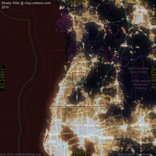
Analysis of Shady Hills night lights 2016
Square area 10x10 km:
 1.79%
1.79%90-99
1.79%80-89
2.98%70-79
5.56%60-69
36.11%50-59
22.42%40-49
8.53%30-39
3.97%20-29
11.31%10-19
5.56%0-9
0%Square area 50x50 km:
2.97%90-99
4.05%80-89
3.15%70-79
5.37%60-69
15.01%50-59
6.2%40-49
4.08%30-39
4.83%20-29
8.55%10-19
12.78%0-9
33%Clear (daylight) street map image can be seen on geolist.org.
Map coordinates:
29° 1' 35.9" North, 83° 14' 45.6" West
28° 24' 36" North, 82° 32' 34.4" West
27° 47' 23.1" North, 81° 50' 23.1" West
Some cities around Shady Hills sort by population:
• Spring Hill
7.6 km =4.7 mi,  12°
12°
• Bayonet Point
16.6 km =10.3 mi,  236°
236°
• Jasmine Estates
19.4 km =12.1 mi,  227°
227°
• Hudson
15.6 km =9.7 mi,  251°
251°
• New Port Richey East
22.2 km =13.8 mi,  221°
221°
• North Weeki Wachee
15.7 km =9.8 mi,  354°
354°
• Brooksville
22 km =13.7 mi,  42°
42°
• Timber Pines
8.9 km =5.5 mi,  318°
318°
4172602 (p: 11,523)
Sources (retrieved 2019-11-25):
» Earth at Night: Flat Maps 2012, 2016