Jasmine Estates night lights from space
Night Light of Jasmine Estates (Florida) from space (United States) Src. Average luminocity for 10x10km area is 76.0615% and for 50x50km: 37.4566%.
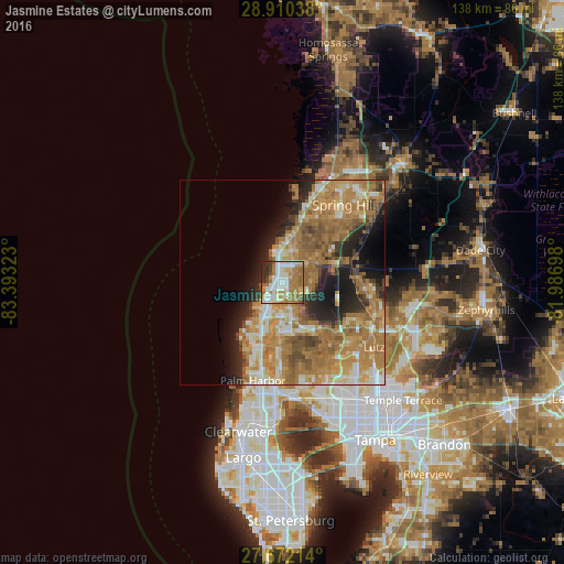
Analysis of Jasmine Estates night lights 2016
Square area 10x10 km:
 16.27%
90-99
24.21%80-89
5.75%70-79
10.12%60-69
26.39%50-59
4.96%40-49
3.77%30-39
3.57%20-29
4.96%10-19
0%0-9
0%Square area 50x50 km:
3.67%90-99
5.53%80-89
4.69%70-79
7.8%60-69
15.81%50-59
5.29%40-49
3.63%30-39
3.05%20-29
5.82%10-19
8.26%0-9
36.46%Clear (daylight) street map image can be seen on geolist.org.
Map coordinates:
28° 54' 37.4" North, 83° 23' 35.6" West
28° 17' 35" North, 82° 41' 24.4" West
27° 40' 19.7" North, 81° 59' 13.1" West
Some cities around Jasmine Estates sort by population:
• Bayonet Point
3.8 km =2.4 mi,  9°
9°
• Holiday
12.7 km =7.9 mi,  202°
202°
• New Port Richey
6.1 km =3.8 mi,  207°
207°
• Elfers
9.1 km =5.7 mi, 200°
• Hudson
7.9 km =4.9 mi,  357°
357°
• Trinity
12.5 km =7.8 mi,  176°
176°
• New Port Richey East
3.7 km =2.3 mi, 183°
• Beacon Square
11.4 km =7.1 mi, 214°
4160100 (p: 18,989)
Sources (retrieved 2019-11-25):
» Earth at Night: Flat Maps 2012, 2016