New Port Richey East night lights from space
Night Light of New Port Richey East (Florida) from space (United States) Src. Average luminocity for 10x10km area is 80.0595% and for 50x50km: 39.5441%.
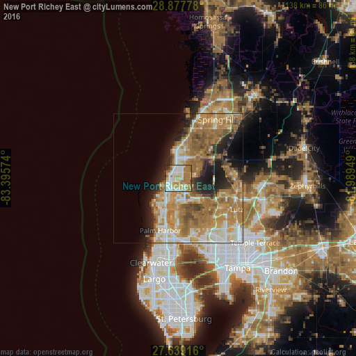
Analysis of New Port Richey East night lights 2016
Square area 10x10 km:
 18.45%
90-99
23.02%80-89
6.75%70-79
19.44%60-69
23.02%50-59
4.17%40-49
2.18%30-39
1.59%20-29
1.39%10-19
0%0-9
0%Square area 50x50 km:
4.77%90-99
7.12%80-89
4.99%70-79
7.71%60-69
14.98%50-59
5.19%40-49
3.53%30-39
2.89%20-29
5.65%10-19
8.23%0-9
34.94%Clear (daylight) street map image can be seen on geolist.org.
Map coordinates:
28° 52' 40" North, 83° 23' 44.7" West
28° 15' 37" North, 82° 41' 33.4" West
27° 38' 21" North, 81° 59' 22.2" West
Some cities around New Port Richey East sort by population:
• Bayonet Point
7.4 km =4.6 mi,  6°
6°
• Holiday
9.3 km =5.8 mi,  209°
209°
• Jasmine Estates
3.7 km =2.3 mi,  3°
3°
• Elfers
5.7 km =3.5 mi, 210°
• Hudson
11.6 km =7.2 mi,  359°
359°
• Trinity
8.9 km =5.5 mi,  173°
173°
• Odessa
12.3 km =7.6 mi,  126°
126°
• Beacon Square
8.4 km =5.2 mi,  226°
226°
7260490 (p: 10,036)
Sources (retrieved 2019-11-25):
» Earth at Night: Flat Maps 2012, 2016