Brooksville night lights from space
Night Light of Brooksville (Florida) from space (United States) Src. Average luminocity for 10x10km area is 40.6723% and for 50x50km: 21.9378%.
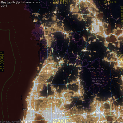
Analysis of Brooksville night lights 2016
Square area 10x10 km:
 3.03%
3.03%90-99
3.79%80-89
3.6%70-79
3.03%60-69
16.86%50-59
7.39%40-49
6.25%30-39
8.33%20-29
17.61%10-19
24.24%0-9
5.87%Square area 50x50 km:
1%90-99
1.23%80-89
1.37%70-79
2.39%60-69
9.79%50-59
5.58%40-49
3.84%30-39
4.07%20-29
5.38%10-19
11.75%0-9
53.6%Clear (daylight) street map image can be seen on geolist.org.
Map coordinates:
29° 10' 16.7" North, 83° 5' 34.9" West
28° 33' 19.9" North, 82° 23' 23.7" West
27° 56' 10.1" North, 81° 41' 12.4" West
Some cities around Brooksville sort by population:
• Spring Hill
15.9 km =9.9 mi,  236°
236°
• Shady Hills
22 km =13.7 mi,  222°
222°
• North Weeki Wachee
16.5 km =10.3 mi,  267°
267°
• Sugarmill Woods
22.7 km =14.1 mi,  329°
329°
• Dade City
28.5 km =17.7 mi,  138°
138°
• Inverness Highlands South
27.7 km =17.2 mi,  10°
10°
• Timber Pines
22.9 km =14.2 mi,  245°
245°
• Floral City
23.5 km =14.6 mi,  22°
22°
4148986 (p: 7,854)
Sources (retrieved 2019-11-25):
» Earth at Night: Flat Maps 2012, 2016