Lady Lake night lights from space
Night Light of Lady Lake (Florida) from space (United States) Src. Average luminocity for 10x10km area is 64.506% and for 50x50km: 29.767%.
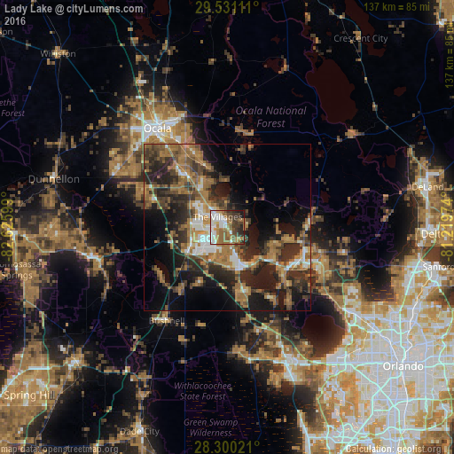
Analysis of Lady Lake night lights 2016
Square area 10x10 km:
 13.49%
90-99
13.69%80-89
3.77%70-79
4.76%60-69
20.04%50-59
14.48%40-49
8.53%30-39
12.7%20-29
5.75%10-19
2.78%0-9
0%Square area 50x50 km:
3%90-99
3.34%80-89
1.43%70-79
2.47%60-69
11.01%50-59
5.36%40-49
5.57%30-39
7.31%20-29
10.67%10-19
13.85%0-9
35.98%Clear (daylight) street map image can be seen on geolist.org.
Map coordinates:
29° 31' 52" North, 82° 37' 33.6" West
28° 55' 3" North, 81° 55' 22.3" West
28° 18' 0.8" North, 81° 13' 11.1" West
Some cities around Lady Lake sort by population:
• The Villages
4.1 km =2.5 mi,  297°
297°
• Leesburg
12.6 km =7.8 mi,  159°
159°
• Eustis
24.2 km =15 mi,  107°
107°
• Tavares
23 km =14.3 mi,  123°
123°
• Mount Dora
30 km =18.6 mi, 115°
• Silver Springs
35.7 km =22.2 mi,  338°
338°
• Wildwood
12.8 km =8 mi,  243°
243°
• Silver Springs Shores
22.9 km =14.2 mi, 335°
4161118 (p: 14,717)
Sources (retrieved 2019-11-25):
» Earth at Night: Flat Maps 2012, 2016