Takoma Park night lights from space
Night Light of Takoma Park (Maryland) from space (United States) Src. Average luminocity for 10x10km area is 97.224% and for 50x50km: 80.167%.
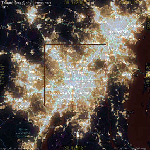
Analysis of Takoma Park night lights 2016
Square area 10x10 km:
 61.85%
90-99
24.35%80-89
12.82%70-79
0.97%60-69
0%50-59
0%40-49
0%30-39
0%20-29
0%10-19
0%0-9
0%Square area 50x50 km:
25.77%90-99
20.21%80-89
11.6%70-79
13.94%60-69
10.79%50-59
7.67%40-49
4.07%30-39
3.06%20-29
1.83%10-19
0.89%0-9
0.18%Clear (daylight) street map image can be seen on geolist.org.
Map coordinates:
39° 31' 20.6" North, 77° 42' 38.2" West
38° 58' 40.4" North, 77° 0' 26.9" West
38° 25' 45" North, 76° 18' 15.7" West
Some cities around Takoma Park sort by population:
• Silver Spring
2.1 km =1.3 mi,  311°
311°
• Chillum
2.1 km =1.3 mi,  137°
137°
• Langley Park
2.6 km =1.6 mi,  61°
61°
• Adelphi
4.2 km =2.6 mi,  47°
47°
• Chevy Chase
5.4 km =3.4 mi,  253°
253°
• Mount Rainier
5.5 km =3.4 mi, 137°
• Four Corners
4.7 km =2.9 mi,  354°
354°
• Forest Glen
5.8 km =3.6 mi, 314°
4370890 (p: 17,713)
Sources (retrieved 2019-11-25):
» Earth at Night: Flat Maps 2012, 2016