Four Corners night lights from space
Night Light of Four Corners (Maryland) from space (United States) Src. Average luminocity for 10x10km area is 92.2614% and for 50x50km: 78.0472%.
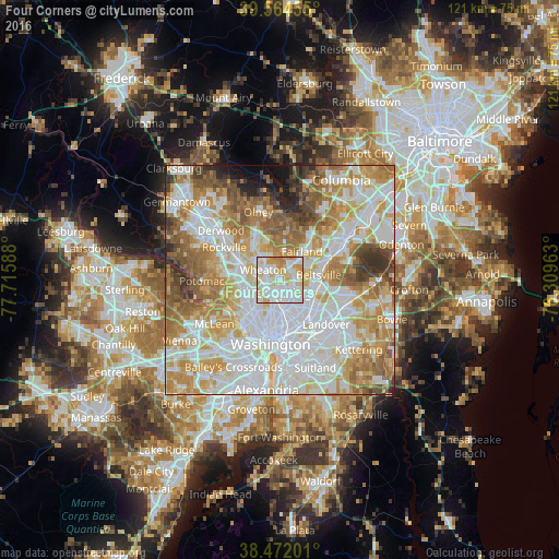
Analysis of Four Corners night lights 2016
Square area 10x10 km:
 34.74%
90-99
31.98%80-89
18.99%70-79
10.71%60-69
3.57%50-59
0%40-49
0%30-39
0%20-29
0%10-19
0%0-9
0%Square area 50x50 km:
25.13%90-99
19.54%80-89
10.6%70-79
13.13%60-69
10.36%50-59
7.92%40-49
4.52%30-39
3.69%20-29
2.51%10-19
1.96%0-9
0.63%Clear (daylight) street map image can be seen on geolist.org.
Map coordinates:
39° 33' 52.4" North, 77° 42' 57.2" West
39° 1' 13.4" North, 77° 0' 45.9" West
38° 28' 19.2" North, 76° 18' 34.7" West
Some cities around Four Corners sort by population:
• Silver Spring
3.5 km =2.2 mi,  199°
199°
• Wheaton
4.3 km =2.7 mi,  300°
300°
• Langley Park
4.4 km =2.7 mi,  142°
142°
• White Oak
2.8 km =1.7 mi,  38°
38°
• Adelphi
4 km =2.5 mi,  118°
118°
• Kemp Mill
2.1 km =1.3 mi,  345°
345°
• Forest Glen
3.7 km =2.3 mi,  259°
259°
• Hillandale
3.4 km =2.1 mi,  78°
78°
4355400 (p: 7,945)
Sources (retrieved 2019-11-25):
» Earth at Night: Flat Maps 2012, 2016