Chevy Chase night lights from space
Night Light of Chevy Chase (Washington, D.C.) from space (United States) Src. Average luminocity for 10x10km area is 96.2597% and for 50x50km: 78.8854%.
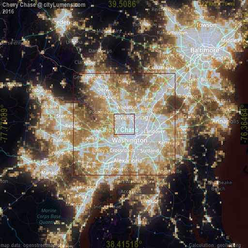
Analysis of Chevy Chase night lights 2016
Square area 10x10 km:
 52.6%
52.6%90-99
29.87%80-89
14.29%70-79
3.25%60-69
0%50-59
0%40-49
0%30-39
0%20-29
0%10-19
0%0-9
0%Square area 50x50 km:
25.09%90-99
19.11%80-89
11.06%70-79
13.69%60-69
12.1%50-59
8.31%40-49
3.84%30-39
2.61%20-29
2.29%10-19
1.25%0-9
0.65%Clear (daylight) street map image can be seen on geolist.org.
Map coordinates:
39° 30' 31" North, 77° 46' 15.2" West
38° 57' 50.4" North, 77° 4' 3.9" West
38° 24' 54.6" North, 76° 21' 52.7" West
Some cities around Chevy Chase sort by population:
• Silver Spring
4.7 km =2.9 mi,  50°
50°
• Bethesda
3.4 km =2.1 mi,  303°
303°
• Chillum
6.7 km =4.2 mi,  90°
90°
• Takoma Park
5.4 km =3.4 mi,  73°
73°
• Shaw
7 km =4.3 mi,  145°
145°
• Adams Morgan
5.2 km =3.2 mi, 154°
• South Kensington
6.2 km =3.9 mi,  350°
350°
• Forest Glen
5.7 km =3.5 mi,  11°
11°
4138011 (p: 9,545)
Sources (retrieved 2019-11-25):
» Earth at Night: Flat Maps 2012, 2016