Sun Village night lights from space
Night Light of Sun Village (California) from space (United States) Src. Average luminocity for 10x10km area is 25.9301% and for 50x50km: 13.6813%.
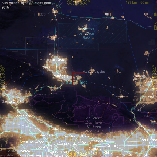
Analysis of Sun Village night lights 2016
Square area 10x10 km:
 0%
0%90-99
0.35%80-89
0.35%70-79
0.7%60-69
13.11%50-59
5.42%40-49
9.79%30-39
6.64%20-29
7.87%10-19
20.63%0-9
35.14%Square area 50x50 km:
2.6%90-99
2.52%80-89
1.07%70-79
1.3%60-69
3.22%50-59
1.9%40-49
1.87%30-39
1.8%20-29
3.4%10-19
5.55%0-9
74.78%Clear (daylight) street map image can be seen on geolist.org.
Map coordinates:
35° 8' 11.6" North, 118° 39' 35.6" West
34° 33' 34.3" North, 117° 57' 24.3" West
33° 58' 42.5" North, 117° 15' 13.1" West
Some cities around Sun Village sort by population:
• Lancaster
22.5 km =14 mi,  313°
313°
• Palmdale
14.8 km =9.2 mi,  278°
278°
• Rosamond
38.8 km =24.1 mi,  330°
330°
• Phelan
38.2 km =23.7 mi,  112°
112°
• Lake Los Angeles
13.2 km =8.2 mi,  63°
63°
• Quartz Hill
25.8 km =16 mi,  291°
291°
• Acton
24.1 km =15 mi,  245°
245°
• Piñon Hills
31.7 km =19.7 mi,  116°
116°
7315210 (p: 11,565)
Sources (retrieved 2019-11-25):
» Earth at Night: Flat Maps 2012, 2016