Lake Los Angeles night lights from space
Night Light of Lake Los Angeles (California) from space (United States) Src. Average luminocity for 10x10km area is 8.5105% and for 50x50km: 6.0119%.
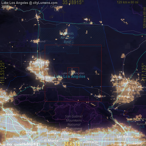
Analysis of Lake Los Angeles night lights 2016
Square area 10x10 km:
 0%
0%90-99
0%80-89
0%70-79
0.87%60-69
4.2%50-59
2.62%40-49
2.27%30-39
2.27%20-29
1.75%10-19
0%0-9
86.01%Square area 50x50 km:
0.77%90-99
0.82%80-89
0.38%70-79
0.43%60-69
1.45%50-59
0.99%40-49
1.09%30-39
1.31%20-29
1.98%10-19
3.21%0-9
87.57%Clear (daylight) street map image can be seen on geolist.org.
Map coordinates:
35° 11' 20.9" North, 118° 31' 52.5" West
34° 36' 45" North, 117° 49' 41.2" West
34° 1' 54.5" North, 117° 7' 30" West
Some cities around Lake Los Angeles sort by population:
• Lancaster
29.8 km =18.5 mi,  288°
288°
• Palmdale
26.6 km =16.5 mi,  262°
262°
• Adelanto
38.5 km =23.9 mi,  94°
94°
• Phelan
31.3 km =19.4 mi,  131°
131°
• Sun Village
13.2 km =8.2 mi,  243°
243°
• Quartz Hill
35.9 km =22.3 mi,  275°
275°
• Acton
37.3 km =23.2 mi, 244°
• Piñon Hills
25.9 km =16.1 mi,  140°
140°
5364571 (p: 12,328)
Sources (retrieved 2019-11-25):
» Earth at Night: Flat Maps 2012, 2016