Piñon Hills night lights from space
Night Light of Piñon Hills (California) from space (United States) Src. Average luminocity for 10x10km area is 2.6836% and for 50x50km: 5.6666%.
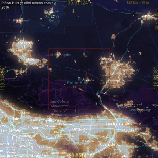
Analysis of Piñon Hills night lights 2016
Square area 10x10 km:
 0%
0%90-99
0%80-89
0%70-79
0%60-69
0.7%50-59
1.4%40-49
0.35%30-39
1.05%20-29
0.17%10-19
1.22%0-9
95.1%Square area 50x50 km:
0.18%90-99
0.28%80-89
0.12%70-79
0.37%60-69
1.9%50-59
1.41%40-49
1.58%30-39
1.81%20-29
1.63%10-19
3.5%0-9
87.23%Clear (daylight) street map image can be seen on geolist.org.
Map coordinates:
35° 0' 40.5" North, 118° 20' 59.5" West
34° 25' 60" North, 117° 38' 48.2" West
33° 51' 5" North, 116° 56' 37" West
Some cities around Piñon Hills sort by population:
• Victorville
34.5 km =21.4 mi,  70°
70°
• Hesperia
31.7 km =19.7 mi,  91°
91°
• Adelanto
27.4 km =17 mi,  52°
52°
• Phelan
6.9 km =4.3 mi,  96°
96°
• Lake Los Angeles
25.9 km =16.1 mi,  320°
320°
• Sun Village
31.7 km =19.7 mi,  296°
296°
• Oak Hills
25 km =15.5 mi, 102°
• Spring Valley Lake
35.3 km =21.9 mi,  79°
79°
5383526 (p: 7,272)
Sources (retrieved 2019-11-25):
» Earth at Night: Flat Maps 2012, 2016