Summerside night lights from space
Night Light of Summerside (Ohio) from space (United States) Src. Average luminocity for 10x10km area is 70.1932% and for 50x50km: 43.3271%.
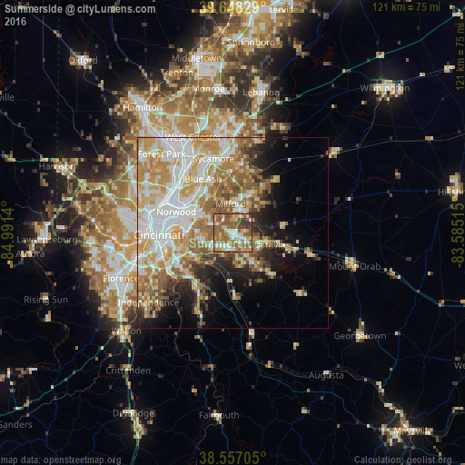
Analysis of Summerside night lights 2016
Square area 10x10 km:
 9.9%
9.9%90-99
12.82%80-89
11.69%70-79
11.2%60-69
18.51%50-59
23.54%40-49
7.47%30-39
4.87%20-29
0%10-19
0%0-9
0%Square area 50x50 km:
9.07%90-99
9.71%80-89
6.48%70-79
7.51%60-69
7.2%50-59
6.95%40-49
3.12%30-39
3.01%20-29
4.64%10-19
7.8%0-9
34.51%Clear (daylight) street map image can be seen on geolist.org.
Map coordinates:
39° 38' 53.8" North, 84° 59' 29" West
39° 6' 17.2" North, 84° 17' 17.8" West
38° 33' 25.4" North, 83° 35' 6.5" West
Some cities around Summerside sort by population:
• Forestville
5.9 km =3.7 mi,  235°
235°
• Madeira
11.6 km =7.2 mi,  325°
325°
• Dry Run
3.6 km =2.2 mi,  269°
269°
• Withamsville
4.7 km =2.9 mi,  180°
180°
• Kenwood
13.6 km =8.5 mi, 329°
• Milford
7.9 km =4.9 mi,  356°
356°
• The Village of Indian Hill
9.2 km =5.7 mi, 334°
• Turpin Hills
7.9 km =4.9 mi, 274°
4525829 (p: 5,083)
Sources (retrieved 2019-11-25):
» Earth at Night: Flat Maps 2012, 2016