Dry Run night lights from space
Night Light of Dry Run (Ohio) from space (United States) Src. Average luminocity for 10x10km area is 72.526% and for 50x50km: 48.1783%.
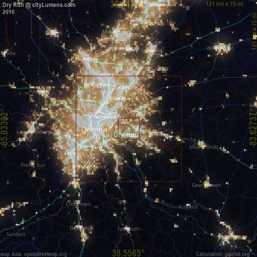
Analysis of Dry Run night lights 2016
Square area 10x10 km:
 10.88%
90-99
13.15%80-89
11.04%70-79
9.58%60-69
26.3%50-59
27.76%40-49
1.3%30-39
0%20-29
0%10-19
0%0-9
0%Square area 50x50 km:
10.05%90-99
10.93%80-89
7.39%70-79
8.8%60-69
8%50-59
7.32%40-49
3.54%30-39
3.13%20-29
4.89%10-19
7.78%0-9
28.16%Clear (daylight) street map image can be seen on geolist.org.
Map coordinates:
39° 38' 51.9" North, 85° 2' 1" West
39° 6' 15.2" North, 84° 19' 49.8" West
38° 33' 23.4" North, 83° 37' 38.5" West
Some cities around Dry Run sort by population:
• Fort Thomas
10.6 km =6.6 mi,  252°
252°
• Forestville
3.5 km =2.2 mi,  201°
201°
• Madeira
10 km =6.2 mi,  343°
343°
• Withamsville
5.9 km =3.7 mi,  142°
142°
• Milford
8.5 km =5.3 mi,  21°
21°
• The Village of Indian Hill
8.4 km =5.2 mi,  357°
357°
• Turpin Hills
4.3 km =2.7 mi,  278°
278°
• Summerside
3.6 km =2.2 mi,  89°
89°
4510342 (p: 7,281)
Sources (retrieved 2019-11-25):
» Earth at Night: Flat Maps 2012, 2016