Withamsville night lights from space
Night Light of Withamsville (Ohio) from space (United States) Src. Average luminocity for 10x10km area is 61.7581% and for 50x50km: 38.1735%.
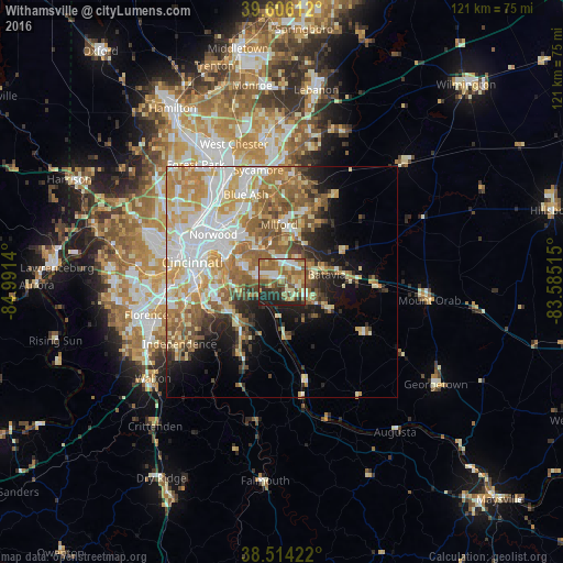
Analysis of Withamsville night lights 2016
Square area 10x10 km:
 7.95%
7.95%90-99
13.47%80-89
9.74%70-79
7.63%60-69
16.07%50-59
15.58%40-49
5.52%30-39
3.73%20-29
15.1%10-19
5.19%0-9
0%Square area 50x50 km:
7.59%90-99
8.3%80-89
5.81%70-79
6.29%60-69
6.54%50-59
6.58%40-49
3.04%30-39
2.74%20-29
4.38%10-19
7.53%0-9
41.19%Clear (daylight) street map image can be seen on geolist.org.
Map coordinates:
39° 36' 22" North, 84° 59' 29" West
39° 3' 44.2" North, 84° 17' 17.8" West
38° 30' 51.2" North, 83° 35' 6.5" West
Some cities around Withamsville sort by population:
• Fort Thomas
13.8 km =8.6 mi,  275°
275°
• Forestville
5.1 km =3.2 mi,  286°
286°
• Dry Run
5.9 km =3.7 mi,  322°
322°
• Milford
12.6 km =7.8 mi,  357°
357°
• Cold Spring
13.9 km =8.6 mi,  251°
251°
• The Village of Indian Hill
13.6 km =8.5 mi,  342°
342°
• Turpin Hills
9.5 km =5.9 mi,  303°
303°
• Summerside
4.7 km =2.9 mi,  0°
0°
4528596 (p: 7,021)
Sources (retrieved 2019-11-25):
» Earth at Night: Flat Maps 2012, 2016