Kenwood night lights from space
Night Light of Kenwood (Ohio) from space (United States) Src. Average luminocity for 10x10km area is 78.2971% and for 50x50km: 60.4961%.
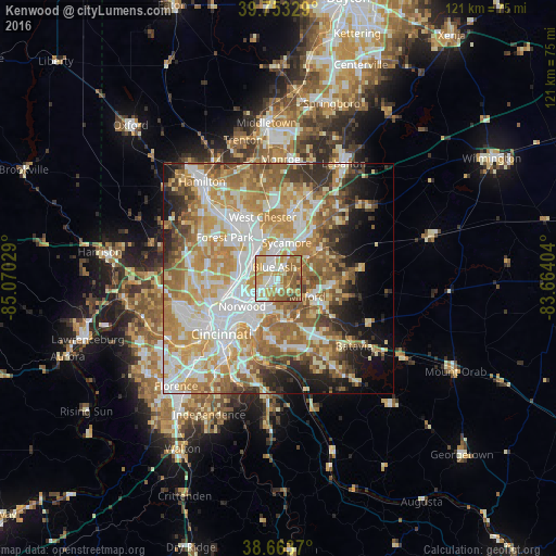
Analysis of Kenwood night lights 2016
Square area 10x10 km:
 12.99%
90-99
21.27%80-89
14.45%70-79
19.32%60-69
16.56%50-59
11.85%40-49
3.41%30-39
0.16%20-29
0%10-19
0%0-9
0%Square area 50x50 km:
12.43%90-99
13.87%80-89
8.84%70-79
11.8%60-69
11.18%50-59
9.07%40-49
4.73%30-39
4.21%20-29
5.48%10-19
7.17%0-9
11.22%Clear (daylight) street map image can be seen on geolist.org.
Map coordinates:
39° 45' 11.8" North, 85° 4' 13" West
39° 12' 38.2" North, 84° 22' 1.8" West
38° 39' 49.3" North, 83° 39' 50.5" West
Some cities around Kenwood sort by population:
• Sharonville
7.5 km =4.7 mi,  328°
328°
• Blue Ash
2.6 km =1.6 mi,  338°
338°
• Montgomery
2.2 km =1.4 mi,  30°
30°
• Reading
6.6 km =4.1 mi,  282°
282°
• Madeira
2.2 km =1.4 mi,  171°
171°
• Milford
7.4 km =4.6 mi,  122°
122°
• The Village of Indian Hill
4.4 km =2.7 mi,  141°
141°
• Deer Park
2.4 km =1.5 mi,  256°
256°
4515813 (p: 6,981)
Sources (retrieved 2019-11-25):
» Earth at Night: Flat Maps 2012, 2016