Summerfield night lights from space
Night Light of Summerfield (North Carolina) from space (United States) Src. Average luminocity for 10x10km area is 30.8217% and for 50x50km: 38.6561%.
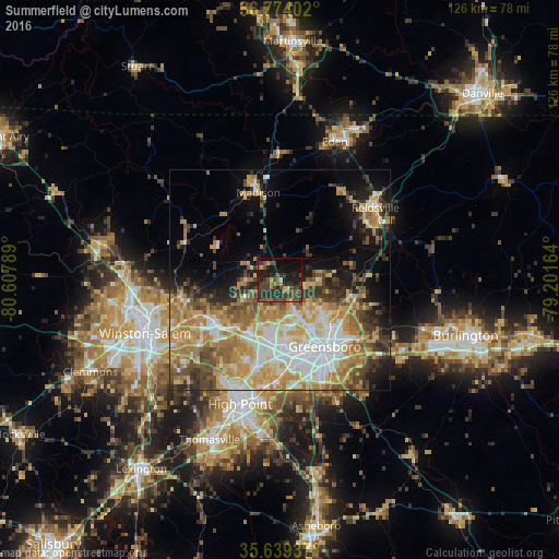
Analysis of Summerfield night lights 2016
Square area 10x10 km:
 0%
0%90-99
0%80-89
3.15%70-79
3.15%60-69
3.85%50-59
7.34%40-49
13.29%30-39
14.69%20-29
16.61%10-19
22.73%0-9
15.21%Square area 50x50 km:
6.51%90-99
6.2%80-89
7.03%70-79
7.57%60-69
6.95%50-59
4.46%40-49
5.06%30-39
5.53%20-29
4.99%10-19
9.06%0-9
36.64%Clear (daylight) street map image can be seen on geolist.org.
Map coordinates:
36° 46' 26.5" North, 80° 36' 28.4" West
36° 12' 31.5" North, 79° 54' 17.1" West
35° 38' 21.7" North, 79° 12' 5.9" West
Some cities around Summerfield sort by population:
• Greensboro
18.2 km =11.3 mi,  146°
146°
• Winston-Salem
32.8 km =20.4 mi,  248°
248°
• High Point
29.6 km =18.4 mi,  197°
197°
• Kernersville
18.1 km =11.2 mi,  236°
236°
• Reidsville
27 km =16.8 mi,  52°
52°
• Archdale
33.3 km =20.7 mi,  190°
190°
• Oak Ridge
8.5 km =5.3 mi, 242°
• Stokesdale
7.4 km =4.6 mi,  295°
295°
4493990 (p: 10,861)
Sources (retrieved 2019-11-25):
» Earth at Night: Flat Maps 2012, 2016