Stokesdale night lights from space
Night Light of Stokesdale (North Carolina) from space (United States) Src. Average luminocity for 10x10km area is 23.1941% and for 50x50km: 36.0802%.
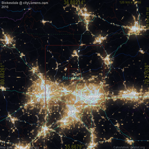
Analysis of Stokesdale night lights 2016
Square area 10x10 km:
 0%
0%90-99
0%80-89
2.8%70-79
4.02%60-69
5.07%50-59
2.97%40-49
5.07%30-39
9.44%20-29
9.44%10-19
24.3%0-9
36.89%Square area 50x50 km:
7.03%90-99
6.48%80-89
6.47%70-79
6.61%60-69
6.65%50-59
3.83%40-49
3.83%30-39
3.8%20-29
3.85%10-19
7.08%0-9
44.36%Clear (daylight) street map image can be seen on geolist.org.
Map coordinates:
36° 48' 7.7" North, 80° 40' 57.4" West
36° 14' 13.5" North, 79° 58' 46.1" West
35° 40' 4.4" North, 79° 16' 34.9" West
Some cities around Stokesdale sort by population:
• Greensboro
24.9 km =15.5 mi,  137°
137°
• Winston-Salem
28.2 km =17.5 mi,  237°
237°
• High Point
31.4 km =19.5 mi,  184°
184°
• Kernersville
15.5 km =9.6 mi,  212°
212°
• Eden
33.8 km =21 mi,  34°
34°
• Reidsville
31.1 km =19.3 mi,  65°
65°
• Summerfield
7.4 km =4.6 mi,  115°
115°
• Oak Ridge
7.1 km =4.4 mi,  186°
186°
4493547 (p: 5,340)
Sources (retrieved 2019-11-25):
» Earth at Night: Flat Maps 2012, 2016