Reidsville night lights from space
Night Light of Reidsville (North Carolina) from space (United States) Src. Average luminocity for 10x10km area is 43.2273% and for 50x50km: 14.2091%.
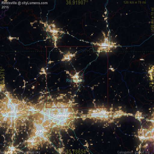
Analysis of Reidsville night lights 2016
Square area 10x10 km:
 4.72%
4.72%90-99
5.24%80-89
8.04%70-79
10.84%60-69
6.29%50-59
4.2%40-49
2.62%30-39
9.62%20-29
13.81%10-19
28.5%0-9
6.12%Square area 50x50 km:
0.68%90-99
1.15%80-89
2.16%70-79
2.34%60-69
2.03%50-59
2.39%40-49
2.51%30-39
4.1%20-29
4.14%10-19
10.73%0-9
67.77%Clear (daylight) street map image can be seen on geolist.org.
Map coordinates:
36° 55' 8.7" North, 80° 22' 3.4" West
36° 21' 17.5" North, 79° 39' 52.1" West
35° 47' 11.5" North, 78° 57' 40.9" West
Some cities around Reidsville sort by population:
• Greensboro
33.4 km =20.8 mi,  200°
200°
• Burlington
35.3 km =21.9 mi,  144°
144°
• Danville
35.2 km =21.9 mi,  43°
43°
• Eden
17.4 km =10.8 mi,  328°
328°
• Summerfield
27 km =16.8 mi,  232°
232°
• Elon
31.4 km =19.5 mi,  153°
153°
• Gibsonville
29.8 km =18.5 mi,  158°
158°
• Stokesdale
31.1 km =19.3 mi,  245°
245°
4487682 (p: 14,067)
Sources (retrieved 2019-11-25):
» Earth at Night: Flat Maps 2012, 2016