Archdale night lights from space
Night Light of Archdale (North Carolina) from space (United States) Src. Average luminocity for 10x10km area is 78.6868% and for 50x50km: 48.4188%.
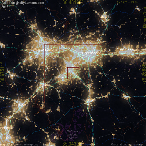
Analysis of Archdale night lights 2016
Square area 10x10 km:
 18.68%
90-99
19.6%80-89
11.54%70-79
13.74%60-69
19.78%50-59
11.72%40-49
3.3%30-39
1.47%20-29
0.18%10-19
0%0-9
0%Square area 50x50 km:
8.91%90-99
8.61%80-89
8.24%70-79
8.87%60-69
8.33%50-59
5.81%40-49
6.17%30-39
6.1%20-29
7.39%10-19
12.78%0-9
18.8%Clear (daylight) street map image can be seen on geolist.org.
Map coordinates:
36° 28' 55.1" North, 80° 40' 30.4" West
35° 54' 52.5" North, 79° 58' 19.1" West
35° 20' 35.1" North, 79° 16' 7.9" West
Some cities around Archdale sort by population:
• Greensboro
23.9 km =14.9 mi,  42°
42°
• High Point
5.5 km =3.4 mi,  326°
326°
• Thomasville
10.5 km =6.5 mi,  250°
250°
• Asheboro
27.1 km =16.8 mi,  148°
148°
• Kernersville
24.6 km =15.3 mi,  338°
338°
• Lexington
27.3 km =17 mi, 248°
• Oak Ridge
28.8 km =17.9 mi,  356°
356°
• Trinity
2.8 km =1.7 mi,  217°
217°
4452871 (p: 11,564)
Sources (retrieved 2019-11-25):
» Earth at Night: Flat Maps 2012, 2016