Sulphur night lights from space
Night Light of Sulphur (Oklahoma) from space (United States) Src. Average luminocity for 10x10km area is 13.9476% and for 50x50km: 3.3856%.
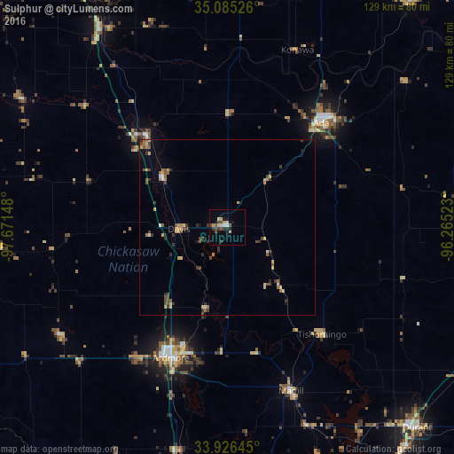
Analysis of Sulphur night lights 2016
Square area 10x10 km:
 1.05%
1.05%90-99
1.22%80-89
3.85%70-79
0.87%60-69
0%50-59
2.62%40-49
2.97%30-39
2.62%20-29
1.57%10-19
5.42%0-9
77.8%Square area 50x50 km:
0.16%90-99
0.16%80-89
0.67%70-79
0.48%60-69
0.43%50-59
0.48%40-49
0.82%30-39
0.86%20-29
0.36%10-19
0.74%0-9
94.82%Clear (daylight) street map image can be seen on geolist.org.
Map coordinates:
35° 5' 6.9" North, 97° 40' 17.3" West
34° 30' 28.3" North, 96° 58' 6.1" West
33° 55' 35.2" North, 96° 15' 54.8" West
Some cities around Sulphur sort by population:
• Ardmore
40.4 km =25.1 mi,  203°
203°
• Ada
39.8 km =24.7 mi,  41°
41°
• Durant
79.3 km =49.3 mi,  136°
136°
• Noble
80.3 km =49.9 mi,  330°
330°
• Purcell
66.7 km =41.4 mi, 327°
• Pauls Valley
34.7 km =21.6 mi,  318°
318°
• Holdenville
82.2 km =51.1 mi, 39°
• Lone Grove
45.8 km =28.5 mi,  216°
216°
4552519 (p: 5,097)
Sources (retrieved 2019-11-25):
» Earth at Night: Flat Maps 2012, 2016