Durant night lights from space
Night Light of Durant (Oklahoma) from space (United States) Src. Average luminocity for 10x10km area is 37.5472% and for 50x50km: 5.199%.
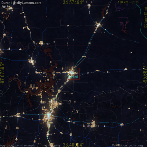
Analysis of Durant night lights 2016
Square area 10x10 km:
 5.59%
5.59%90-99
5.24%80-89
7.34%70-79
3.85%60-69
3.67%50-59
7.87%40-49
3.67%30-39
9.09%20-29
7.69%10-19
23.25%0-9
22.73%Square area 50x50 km:
0.26%90-99
0.26%80-89
0.75%70-79
0.56%60-69
0.69%50-59
1.1%40-49
0.9%30-39
1.33%20-29
1.28%10-19
4.57%0-9
88.28%Clear (daylight) street map image can be seen on geolist.org.
Map coordinates:
34° 34' 29.8" North, 97° 4' 26.2" West
33° 59' 38.4" North, 96° 22' 15" West
33° 24' 32.5" North, 95° 40' 3.7" West
Some cities around Durant sort by population:
• Sherman
45.5 km =28.3 mi,  208°
208°
• Ardmore
73.9 km =45.9 mi,  285°
285°
• Denison
30.6 km =19 mi, 210°
• Anna
73.6 km =45.7 mi,  192°
192°
• Bonham
49.6 km =30.8 mi,  158°
158°
• Melissa
80.9 km =50.3 mi, 193°
• Hugo
79.4 km =49.3 mi,  88°
88°
• Sulphur
79.3 km =49.3 mi,  316°
316°
4535414 (p: 17,286)
Sources (retrieved 2019-11-25):
» Earth at Night: Flat Maps 2012, 2016