Ada night lights from space
Night Light of Ada (Oklahoma) from space (United States) Src. Average luminocity for 10x10km area is 44.804% and for 50x50km: 3.3302%.
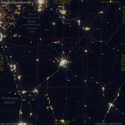
Analysis of Ada night lights 2016
Square area 10x10 km:
 6.78%
6.78%90-99
6.96%80-89
6.23%70-79
5.31%60-69
4.76%50-59
11.9%40-49
7.33%30-39
6.96%20-29
10.81%10-19
28.21%0-9
4.76%Square area 50x50 km:
0.27%90-99
0.29%80-89
0.43%70-79
0.48%60-69
0.38%50-59
0.72%40-49
0.58%30-39
0.84%20-29
0.69%10-19
2.46%0-9
92.85%Clear (daylight) street map image can be seen on geolist.org.
Map coordinates:
35° 21' 0.2" North, 97° 22' 53.3" West
34° 46' 28.3" North, 96° 40' 42" West
34° 11' 41.9" North, 95° 58' 30.8" West
Some cities around Ada sort by population:
• Shawnee
65.4 km =40.6 mi,  339°
339°
• Seminole
50 km =31.1 mi,  0°
0°
• Noble
76.9 km =47.8 mi,  301°
301°
• Tecumseh
58.7 km =36.5 mi, 336°
• Purcell
67.7 km =42.1 mi,  293°
293°
• Pauls Valley
49.8 km =30.9 mi,  265°
265°
• Holdenville
42.5 km =26.4 mi,  36°
36°
• Sulphur
39.8 km =24.7 mi,  221°
221°
4529096 (p: 17,303)
Sources (retrieved 2019-11-25):
» Earth at Night: Flat Maps 2012, 2016