Holdenville night lights from space
Night Light of Holdenville (Oklahoma) from space (United States) Src. Average luminocity for 10x10km area is 13.4038% and for 50x50km: 2.4203%.
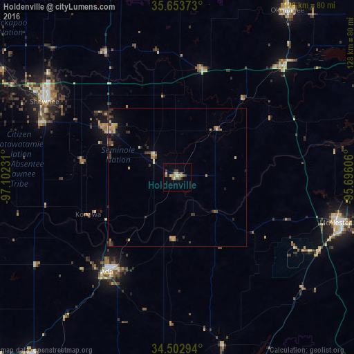
Analysis of Holdenville night lights 2016
Square area 10x10 km:
 0.35%
0.35%90-99
1.05%80-89
4.02%70-79
0.87%60-69
2.45%50-59
2.1%40-49
1.75%30-39
2.8%20-29
1.57%10-19
2.1%0-9
80.94%Square area 50x50 km:
0.06%90-99
0.15%80-89
0.58%70-79
0.33%60-69
0.35%50-59
0.27%40-49
0.45%30-39
0.76%20-29
0.4%10-19
0.9%0-9
95.74%Clear (daylight) street map image can be seen on geolist.org.
Map coordinates:
35° 39' 13.4" North, 97° 6' 8.3" West
35° 4' 49.3" North, 96° 23' 57" West
34° 30' 10.6" North, 95° 41' 45.8" West
Some cities around Holdenville sort by population:
• Shawnee
55.1 km =34.2 mi,  299°
299°
• McAlester
59.6 km =37 mi,  105°
105°
• Ada
42.5 km =26.4 mi,  216°
216°
• Okmulgee
72.3 km =44.9 mi,  33°
33°
• Seminole
29.4 km =18.3 mi, 303°
• Tecumseh
52.7 km =32.7 mi,  291°
291°
• Henryetta
55.1 km =34.2 mi,  43°
43°
• Sulphur
82.2 km =51.1 mi, 219°
4538869 (p: 5,750)
Sources (retrieved 2019-11-25):
» Earth at Night: Flat Maps 2012, 2016