West Concord night lights from space
Night Light of West Concord (Massachusetts) from space (United States) Src. Average luminocity for 10x10km area is 29.1587% and for 50x50km: 46.9302%.
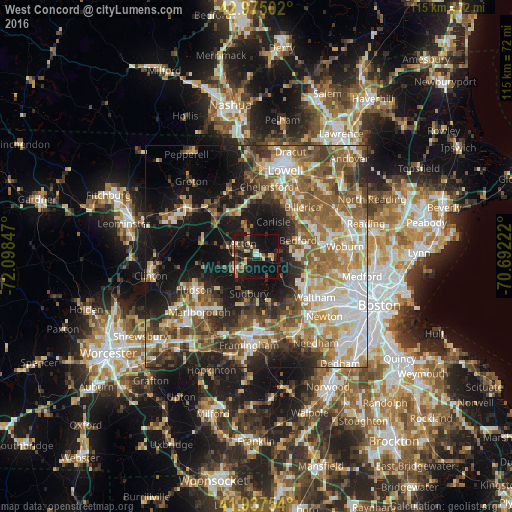
Analysis of West Concord night lights 2016
Square area 10x10 km:
 1.11%
1.11%90-99
3.65%80-89
5.87%70-79
2.38%60-69
2.54%50-59
3.65%40-49
6.19%30-39
4.76%20-29
13.49%10-19
39.05%0-9
17.3%Square area 50x50 km:
8.2%90-99
8.4%80-89
5.99%70-79
5.93%60-69
8.03%50-59
9.76%40-49
7.11%30-39
6.18%20-29
9.36%10-19
17.74%0-9
13.28%Clear (daylight) street map image can be seen on geolist.org.
Map coordinates:
42° 58' 30.1" North, 72° 5' 54.5" West
42° 27' 30.3" North, 71° 23' 43.2" West
41° 56' 15.1" North, 70° 41' 32" West
Some cities around West Concord sort by population:
• Acton
4.3 km =2.7 mi,  313°
313°
• Sudbury
8.5 km =5.3 mi,  191°
191°
• Concord
3.8 km =2.4 mi,  86°
86°
• Wayland
11 km =6.8 mi,  165°
165°
• Bedford
10.4 km =6.5 mi,  69°
69°
• Maynard
5.2 km =3.2 mi,  237°
237°
• Lincoln
8.3 km =5.2 mi,  115°
115°
• Stow
9.4 km =5.8 mi,  255°
255°
4954923 (p: 6,028)
Sources (retrieved 2019-11-25):
» Earth at Night: Flat Maps 2012, 2016