Stow night lights from space
Night Light of Stow (Massachusetts) from space (United States) Src. Average luminocity for 10x10km area is 23.7619% and for 50x50km: 40.1239%.
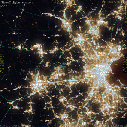
Analysis of Stow night lights 2016
Square area 10x10 km:
 0.63%
0.63%90-99
2.06%80-89
3.33%70-79
1.27%60-69
3.33%50-59
3.49%40-49
4.92%30-39
3.49%20-29
10%10-19
43.33%0-9
24.13%Square area 50x50 km:
5.17%90-99
6.44%80-89
5.06%70-79
4.67%60-69
6.82%50-59
8.84%40-49
6.84%30-39
6.2%20-29
10.88%10-19
22.76%0-9
16.34%Clear (daylight) street map image can be seen on geolist.org.
Map coordinates:
42° 57' 13.7" North, 72° 12' 31.5" West
42° 26' 13.3" North, 71° 30' 20.2" West
41° 54' 57.5" North, 70° 48' 9" West
Some cities around Stow sort by population:
• Marlborough
10.8 km =6.7 mi,  200°
200°
• Acton
8 km =5 mi,  48°
48°
• Sudbury
9.5 km =5.9 mi,  129°
129°
• Concord
13.1 km =8.1 mi,  78°
78°
• Hudson
7.1 km =4.4 mi,  224°
224°
• Maynard
4.6 km =2.9 mi,  94°
94°
• Harvard
9.4 km =5.8 mi,  317°
317°
• West Concord
9.4 km =5.8 mi, 75°
4952217 (p: 6,005)
Sources (retrieved 2019-11-25):
» Earth at Night: Flat Maps 2012, 2016