Concord night lights from space
Night Light of Concord (Massachusetts) from space (United States) Src. Average luminocity for 10x10km area is 25.0063% and for 50x50km: 50.7173%.
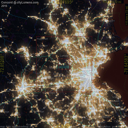
Analysis of Concord night lights 2016
Square area 10x10 km:
 1.27%
1.27%90-99
2.38%80-89
3.97%70-79
1.75%60-69
2.06%50-59
1.59%40-49
4.13%30-39
6.19%20-29
15.08%10-19
43.65%0-9
17.94%Square area 50x50 km:
10.69%90-99
9.25%80-89
6.32%70-79
6.51%60-69
8.29%50-59
9.71%40-49
7.16%30-39
6.09%20-29
9.01%10-19
16.12%0-9
10.84%Clear (daylight) street map image can be seen on geolist.org.
Map coordinates:
42° 58' 37" North, 72° 3' 7.5" West
42° 27' 37.3" North, 71° 20' 56.2" West
41° 56' 22.2" North, 70° 38' 45" West
Some cities around Concord sort by population:
• Lexington
10.3 km =6.4 mi,  98°
98°
• Acton
7.4 km =4.6 mi,  291°
291°
• Sudbury
10.2 km =6.3 mi,  212°
212°
• Wayland
10.9 km =6.8 mi,  185°
185°
• Bedford
6.9 km =4.3 mi,  60°
60°
• Maynard
8.8 km =5.5 mi,  250°
250°
• Lincoln
5.3 km =3.3 mi,  136°
136°
• West Concord
3.8 km =2.4 mi,  266°
266°
4933743 (p: 16,810)
Sources (retrieved 2019-11-25):
» Earth at Night: Flat Maps 2012, 2016