Maynard night lights from space
Night Light of Maynard (Massachusetts) from space (United States) Src. Average luminocity for 10x10km area is 27.7429% and for 50x50km: 42.7973%.
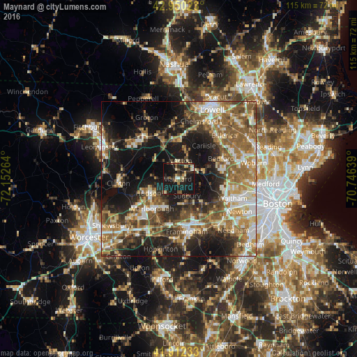
Analysis of Maynard night lights 2016
Square area 10x10 km:
 1.11%
1.11%90-99
3.81%80-89
4.13%70-79
1.27%60-69
2.86%50-59
3.65%40-49
5.71%30-39
3.02%20-29
13.49%10-19
55.4%0-9
5.56%Square area 50x50 km:
5.51%90-99
7%80-89
5.72%70-79
5.45%60-69
7.94%50-59
9.67%40-49
6.76%30-39
5.99%20-29
10.27%10-19
21.62%0-9
14.06%Clear (daylight) street map image can be seen on geolist.org.
Map coordinates:
42° 57' 0.8" North, 72° 9' 9.5" West
42° 26' 0.3" North, 71° 26' 58.2" West
41° 54' 44.4" North, 70° 44' 47" West
Some cities around Maynard sort by population:
• Acton
5.9 km =3.7 mi,  13°
13°
• Sudbury
6.2 km =3.9 mi,  153°
153°
• Concord
8.8 km =5.5 mi,  70°
70°
• Hudson
10.6 km =6.6 mi,  244°
244°
• Wayland
10.7 km =6.6 mi,  137°
137°
• Lincoln
12 km =7.5 mi,  93°
93°
• West Concord
5.2 km =3.2 mi,  57°
57°
• Stow
4.6 km =2.9 mi,  274°
274°
4943490 (p: 10,106)
Sources (retrieved 2019-11-25):
» Earth at Night: Flat Maps 2012, 2016