Eden night lights from space
Night Light of Eden (North Carolina) from space (United States) Src. Average luminocity for 10x10km area is 36.7125% and for 50x50km: 10.7084%.
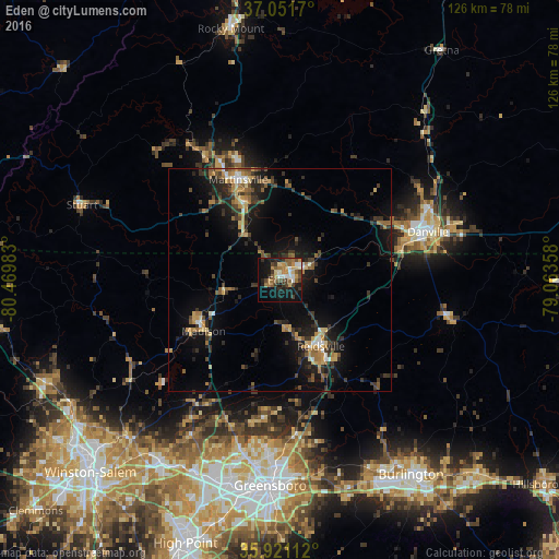
Analysis of Eden night lights 2016
Square area 10x10 km:
 3.85%
3.85%90-99
4.4%80-89
5.49%70-79
5.86%60-69
6.23%50-59
7.14%40-49
6.04%30-39
7.88%20-29
5.86%10-19
28.02%0-9
19.23%Square area 50x50 km:
0.61%90-99
0.79%80-89
1.37%70-79
1.64%60-69
1.49%50-59
1.72%40-49
1.46%30-39
3.34%20-29
2.86%10-19
8.85%0-9
75.88%Clear (daylight) street map image can be seen on geolist.org.
Map coordinates:
37° 3' 6.1" North, 80° 28' 11.4" West
36° 29' 18.5" North, 79° 46' 0.1" West
35° 55' 16" North, 79° 3' 48.9" West
Some cities around Eden sort by population:
• Greensboro
46.3 km =28.8 mi,  182°
182°
• Danville
34.9 km =21.7 mi,  71°
71°
• Reidsville
17.4 km =10.8 mi,  148°
148°
• Martinsville
24.5 km =15.2 mi,  337°
337°
• Summerfield
33.5 km =20.8 mi,  201°
201°
• Collinsville
28.5 km =17.7 mi,  332°
332°
• Oak Ridge
40.3 km =25 mi,  209°
209°
• Stokesdale
33.8 km =21 mi, 214°
4464873 (p: 15,403)
Sources (retrieved 2019-11-25):
» Earth at Night: Flat Maps 2012, 2016