Staunton night lights from space
Night Light of Staunton (Illinois) from space (United States) Src. Average luminocity for 10x10km area is 14.7711% and for 50x50km: 7.9889%.
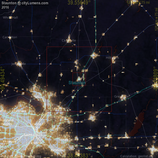
Analysis of Staunton night lights 2016
Square area 10x10 km:
 0%
0%90-99
1.3%80-89
2.44%70-79
0.16%60-69
3.9%50-59
3.25%40-49
2.11%30-39
3.25%20-29
2.6%10-19
7.79%0-9
73.21%Square area 50x50 km:
0.58%90-99
0.87%80-89
0.98%70-79
1.03%60-69
1.61%50-59
1.56%40-49
1.5%30-39
1.48%20-29
1.64%10-19
3.02%0-9
85.72%Clear (daylight) street map image can be seen on geolist.org.
Map coordinates:
39° 33' 23.4" North, 90° 29' 39.6" West
39° 0' 44.2" North, 89° 47' 28.4" West
38° 27' 49.8" North, 89° 5' 17.1" West
Some cities around Staunton sort by population:
• Edwardsville
26.4 km =16.4 mi,  212°
212°
• Wood River
31.4 km =19.5 mi,  237°
237°
• Highland
32.1 km =19.9 mi,  161°
161°
• Bethalto
24.4 km =15.2 mi, 242°
• Litchfield
21.6 km =13.4 mi,  33°
33°
• East Alton
31.3 km =19.4 mi, 242°
• Hillsboro
30.4 km =18.9 mi,  57°
57°
• Carlinville
30.8 km =19.1 mi,  345°
345°
4250608 (p: 5,018)
Sources (retrieved 2019-11-25):
» Earth at Night: Flat Maps 2012, 2016