Bethalto night lights from space
Night Light of Bethalto (Illinois) from space (United States) Src. Average luminocity for 10x10km area is 44.1803% and for 50x50km: 29.9511%.
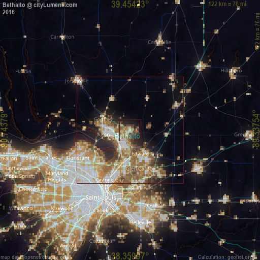
Analysis of Bethalto night lights 2016
Square area 10x10 km:
 3.91%
3.91%90-99
5.44%80-89
7.31%70-79
5.27%60-69
10.2%50-59
10.54%40-49
7.65%30-39
8.16%20-29
12.07%10-19
20.41%0-9
9.01%Square area 50x50 km:
4.86%90-99
5.82%80-89
4.67%70-79
3.9%60-69
5.65%50-59
5.45%40-49
3.6%30-39
3.42%20-29
5.66%10-19
6.56%0-9
50.41%Clear (daylight) street map image can be seen on geolist.org.
Map coordinates:
39° 27' 15.2" North, 90° 44' 37.6" West
38° 54' 33.2" North, 90° 2' 26.4" West
38° 21' 35.9" North, 89° 20' 15.1" West
Some cities around Bethalto sort by population:
• Upper Alton
9.5 km =5.9 mi,  271°
271°
• Alton
12.6 km =7.8 mi,  260°
260°
• Edwardsville
13.3 km =8.3 mi,  145°
145°
• Godfrey
13.7 km =8.5 mi,  292°
292°
• Glen Carbon
18.6 km =11.6 mi,  164°
164°
• Wood River
7.3 km =4.5 mi,  222°
222°
• East Alton
6.9 km =4.3 mi,  242°
242°
• Pontoon Beach
20 km =12.4 mi,  189°
189°
4233662 (p: 9,349)
Sources (retrieved 2019-11-25):
» Earth at Night: Flat Maps 2012, 2016