Hillsboro night lights from space
Night Light of Hillsboro (Illinois) from space (United States) Src. Average luminocity for 10x10km area is 14.2386% and for 50x50km: 3.0788%.
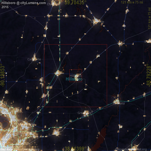
Analysis of Hillsboro night lights 2016
Square area 10x10 km:
 0.81%
0.81%90-99
2.11%80-89
0.97%70-79
2.11%60-69
3.57%50-59
3.08%40-49
2.92%30-39
0.65%20-29
0.81%10-19
3.08%0-9
79.87%Square area 50x50 km:
0.13%90-99
0.24%80-89
0.42%70-79
0.38%60-69
0.62%50-59
0.61%40-49
0.51%30-39
0.62%20-29
0.38%10-19
0.83%0-9
95.26%Clear (daylight) street map image can be seen on geolist.org.
Map coordinates:
39° 42' 15.7" North, 90° 11' 54.7" West
39° 9' 40.6" North, 89° 29' 43.4" West
38° 36' 50.4" North, 88° 47' 32.2" West
Some cities around Hillsboro sort by population:
• Taylorville
46.4 km =28.8 mi,  21°
21°
• Highland
49.3 km =30.6 mi,  197°
197°
• Vandalia
41.2 km =25.6 mi,  122°
122°
• Litchfield
13.8 km =8.6 mi,  276°
276°
• Greenville
30.7 km =19.1 mi,  166°
166°
• Carlinville
35.8 km =22.2 mi,  291°
291°
• Pana
43.8 km =27.2 mi,  54°
54°
• Staunton
30.4 km =18.9 mi,  237°
237°
4240782 (p: 5,726)
Sources (retrieved 2019-11-25):
» Earth at Night: Flat Maps 2012, 2016