Spring Lake Park night lights from space
Night Light of Spring Lake Park (Minnesota) from space (United States) Src. Average luminocity for 10x10km area is 85.2227% and for 50x50km: 54.9497%.
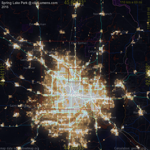
Analysis of Spring Lake Park night lights 2016
Square area 10x10 km:
 23.33%
90-99
24.7%80-89
15.15%70-79
18.18%60-69
12.88%50-59
5.3%40-49
0.45%30-39
0%20-29
0%10-19
0%0-9
0%Square area 50x50 km:
15.95%90-99
12.85%80-89
6.28%70-79
7.32%60-69
8.68%50-59
6.21%40-49
4.98%30-39
3.49%20-29
5.8%10-19
9.62%0-9
18.83%Clear (daylight) street map image can be seen on geolist.org.
Map coordinates:
45° 36' 6.6" North, 93° 56' 28.1" West
45° 6' 27.9" North, 93° 14' 16.8" West
44° 36' 33.6" North, 92° 32' 5.6" West
Some cities around Spring Lake Park sort by population:
• Coon Rapids
4.1 km =2.5 mi,  289°
289°
• Blaine
5.9 km =3.7 mi,  2°
2°
• Brooklyn Center
8.2 km =5.1 mi,  244°
244°
• Fridley
3.1 km =1.9 mi,  219°
219°
• Shoreview
7.8 km =4.8 mi,  114°
114°
• New Brighton
5.5 km =3.4 mi,  148°
148°
• Columbia Heights
7.7 km =4.8 mi,  194°
194°
• Mounds View
2.3 km =1.4 mi,  97°
97°
5048361 (p: 6,473)
Sources (retrieved 2019-11-25):
» Earth at Night: Flat Maps 2012, 2016