Columbia Heights night lights from space
Night Light of Columbia Heights (Minnesota) from space (United States) Src. Average luminocity for 10x10km area is 96% and for 50x50km: 64.3767%.
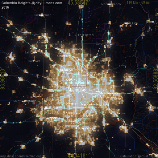
Analysis of Columbia Heights night lights 2016
Square area 10x10 km:
 52.12%
90-99
30.76%80-89
13.18%70-79
2.12%60-69
1.82%50-59
0%40-49
0%30-39
0%20-29
0%10-19
0%0-9
0%Square area 50x50 km:
18.24%90-99
15.2%80-89
7.4%70-79
9%60-69
11.32%50-59
7.96%40-49
5.63%30-39
3.7%20-29
5.67%10-19
8.66%0-9
7.23%Clear (daylight) street map image can be seen on geolist.org.
Map coordinates:
45° 32' 7.7" North, 93° 57' 58.1" West
45° 2' 26.9" North, 93° 15' 46.8" West
44° 32' 30.5" North, 92° 33' 35.6" West
Some cities around Columbia Heights sort by population:
• Minneapolis
6.8 km =4.2 mi,  180°
180°
• Brooklyn Center
6.7 km =4.2 mi,  305°
305°
• Fridley
5 km =3.1 mi,  359°
359°
• New Brighton
5.5 km =3.4 mi,  60°
60°
• Golden Valley
7.6 km =4.7 mi,  242°
242°
• Robbinsdale
6 km =3.7 mi,  260°
260°
• Saint Anthony
4.2 km =2.6 mi,  122°
122°
• Spring Lake Park
7.7 km =4.8 mi,  14°
14°
5021828 (p: 19,715)
Sources (retrieved 2019-11-25):
» Earth at Night: Flat Maps 2012, 2016