New Brighton night lights from space
Night Light of New Brighton (Minnesota) from space (United States) Src. Average luminocity for 10x10km area is 85.3015% and for 50x50km: 59.996%.

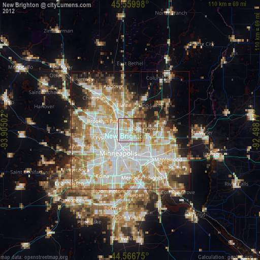
Analysis of New Brighton night lights 2016
Square area 10x10 km:
 28.18%
90-99
26.36%80-89
12.42%70-79
11.97%60-69
13.64%50-59
1.67%40-49
3.79%30-39
1.97%20-29
0%10-19
0%0-9
0%Square area 50x50 km:
17.56%90-99
14.42%80-89
6.76%70-79
8.12%60-69
10.28%50-59
7.03%40-49
4.93%30-39
3.23%20-29
5.01%10-19
8.32%0-9
14.32%Clear (daylight) street map image can be seen on geolist.org.
Map coordinates:
45° 33' 35.9" North, 93° 54' 18.1" West
45° 3' 55.9" North, 93° 12' 6.8" West
44° 34' 0.3" North, 92° 29' 55.6" West
Some cities around New Brighton sort by population:
• Roseville
7.5 km =4.7 mi,  151°
151°
• Fridley
5.3 km =3.3 mi,  295°
295°
• Shoreview
4.6 km =2.9 mi,  70°
70°
• Columbia Heights
5.5 km =3.4 mi,  240°
240°
• Mounds View
4.4 km =2.7 mi,  353°
353°
• Arden Hills
3.9 km =2.4 mi,  115°
115°
• Saint Anthony
5.2 km =3.2 mi,  194°
194°
• Spring Lake Park
5.5 km =3.4 mi,  328°
328°
5039080 (p: 22,351)
Sources (retrieved 2019-11-25):
» Earth at Night: Flat Maps 2012, 2016