South San Jose Hills night lights from space
Night Light of South San Jose Hills (California) from space (United States) Src. Average luminocity for 10x10km area is 88.8444% and for 50x50km: 73.6793%.
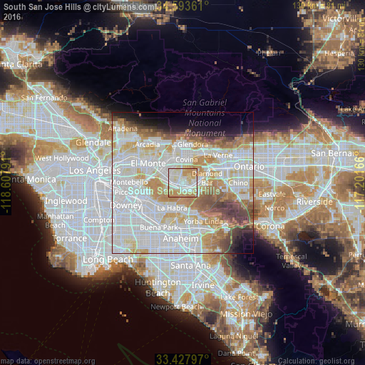

Analysis of South San Jose Hills night lights 2016
Square area 10x10 km:
 26.22%
90-99
29.2%80-89
15.21%70-79
25.52%60-69
3.85%50-59
0%40-49
0%30-39
0%20-29
0%10-19
0%0-9
0%Square area 50x50 km:
27.54%90-99
21.72%80-89
7.52%70-79
9.08%60-69
7.88%50-59
4.43%40-49
4.44%30-39
2.81%20-29
2.4%10-19
4.39%0-9
7.78%Clear (daylight) street map image can be seen on geolist.org.
Map coordinates:
34° 35' 37" North, 118° 36' 28.5" West
34° 0' 46" North, 117° 54' 17.2" West
33° 25' 40.7" North, 117° 12' 6" West
Some cities around South San Jose Hills sort by population:
• West Covina
7 km =4.3 mi,  333°
333°
• Hacienda Heights
6.3 km =3.9 mi,  249°
249°
• Rowland Heights
4.1 km =2.5 mi,  180°
180°
• La Puente
4.2 km =2.6 mi,  281°
281°
• Walnut
3.7 km =2.3 mi,  77°
77°
• Valinda
5.1 km =3.2 mi,  315°
315°
• West Puente Valley
7.3 km =4.5 mi,  306°
306°
• La Habra Heights
7.2 km =4.5 mi,  216°
216°
5397777 (p: 20,551)
Sources (retrieved 2019-11-25):
» Earth at Night: Flat Maps 2012, 2016