Solvang night lights from space
Night Light of Solvang (California) from space (United States) Src. Average luminocity for 10x10km area is 8.1696% and for 50x50km: 1.2834%.
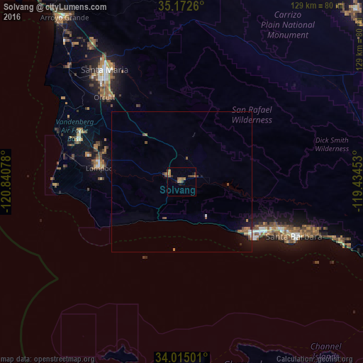
Analysis of Solvang night lights 2016
Square area 10x10 km:
 0%
0%90-99
0%80-89
0.35%70-79
1.75%60-69
3.5%50-59
1.57%40-49
2.97%30-39
1.4%20-29
0%10-19
1.92%0-9
86.54%Square area 50x50 km:
0.08%90-99
0.08%80-89
0.04%70-79
0.19%60-69
0.42%50-59
0.25%40-49
0.34%30-39
0.11%20-29
0.08%10-19
0.88%0-9
97.52%Clear (daylight) street map image can be seen on geolist.org.
Map coordinates:
35° 10' 21.4" North, 120° 50' 26.8" West
34° 35' 45" North, 120° 8' 15.5" West
34° 0' 54" North, 119° 26' 4.3" West
Some cities around Solvang sort by population:
• Santa Maria
48.2 km =30 mi,  325°
325°
• Santa Barbara
44.7 km =27.8 mi,  115°
115°
• Lompoc
29.7 km =18.5 mi,  279°
279°
• Goleta
33.5 km =20.8 mi, 122°
• Orcutt
40.5 km =25.2 mi,  317°
317°
• Isla Vista
32.5 km =20.2 mi,  128°
128°
• Vandenberg Village
32.7 km =20.3 mi,  292°
292°
• Buellton
5.4 km =3.4 mi, 291°
5397059 (p: 5,741)
Sources (retrieved 2019-11-25):
» Earth at Night: Flat Maps 2012, 2016