Vandenberg Village night lights from space
Night Light of Vandenberg Village (California) from space (United States) Src. Average luminocity for 10x10km area is 19.3462% and for 50x50km: 4.5484%.
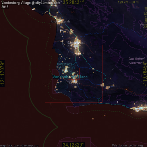
Analysis of Vandenberg Village night lights 2016
Square area 10x10 km:
 0.37%
0.37%90-99
0.37%80-89
0%70-79
2.56%60-69
6.23%50-59
2.75%40-49
8.06%30-39
2.38%20-29
1.83%10-19
32.78%0-9
42.67%Square area 50x50 km:
0.28%90-99
0.42%80-89
0.24%70-79
0.54%60-69
1.13%50-59
0.91%40-49
1.07%30-39
0.77%20-29
0.79%10-19
3.56%0-9
90.3%Clear (daylight) street map image can be seen on geolist.org.
Map coordinates:
35° 17' 3.5" North, 121° 10' 14.8" West
34° 42' 30" North, 120° 28' 3.6" West
34° 7' 41.8" North, 119° 45' 52.3" West
Some cities around Vandenberg Village sort by population:
• Santa Maria
27.4 km =17 mi,  6°
6°
• Lompoc
7.7 km =4.8 mi,  173°
173°
• Orcutt
17.7 km =11 mi, 9°
• Nipomo
37.2 km =23.1 mi,  358°
358°
• Guadalupe
30.8 km =19.1 mi,  342°
342°
• Oceano
45.4 km =28.2 mi, 343°
• Solvang
32.7 km =20.3 mi,  112°
112°
• Buellton
27.3 km =17 mi, 112°
5405737 (p: 6,497)
Sources (retrieved 2019-11-25):
» Earth at Night: Flat Maps 2012, 2016