Sheridan night lights from space
Night Light of Sheridan (Colorado) from space (United States) Src. Average luminocity for 10x10km area is 90.4058% and for 50x50km: 55.7673%.
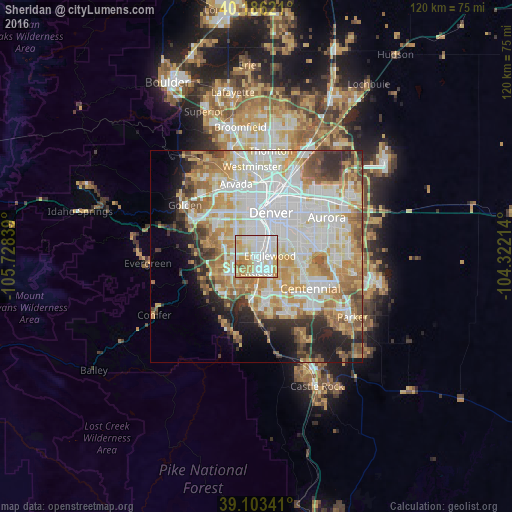
Analysis of Sheridan night lights 2016
Square area 10x10 km:
 30.03%
90-99
31.49%80-89
16.88%70-79
14.29%60-69
6.33%50-59
0.97%40-49
0%30-39
0%20-29
0%10-19
0%0-9
0%Square area 50x50 km:
16.61%90-99
13.35%80-89
7.29%70-79
9.6%60-69
7.24%50-59
4.48%40-49
3.96%30-39
4.25%20-29
5.15%10-19
6.22%0-9
21.86%Clear (daylight) street map image can be seen on geolist.org.
Map coordinates:
40° 11' 10.4" North, 105° 43' 42.2" West
39° 38' 48.9" North, 105° 1' 30.9" West
39° 6' 12.3" North, 104° 19' 19.7" West
Some cities around Sheridan sort by population:
• Lakewood
8 km =5 mi,  323°
323°
• Littleton
3.8 km =2.4 mi,  168°
168°
• Southglenn
9.1 km =5.7 mi,  136°
136°
• Englewood
3.2 km =2 mi,  88°
88°
• Columbine
7.6 km =4.7 mi,  209°
209°
• Greenwood Village
7.2 km =4.5 mi,  117°
117°
• Cherry Hills Village
5.7 km =3.5 mi,  95°
95°
• Glendale
10.2 km =6.3 mi,  50°
50°
5438542 (p: 6,039)
Sources (retrieved 2019-11-25):
» Earth at Night: Flat Maps 2012, 2016