Selma night lights from space
Night Light of Selma (North Carolina) from space (United States) Src. Average luminocity for 10x10km area is 50.1905% and for 50x50km: 23.4807%.
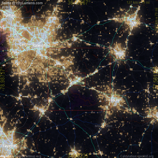
Analysis of Selma night lights 2016
Square area 10x10 km:
 7.33%
7.33%90-99
8.24%80-89
8.61%70-79
3.3%60-69
10.99%50-59
7.14%40-49
5.68%30-39
15.93%20-29
15.93%10-19
16.12%0-9
0.73%Square area 50x50 km:
1.11%90-99
1.33%80-89
3.67%70-79
4.04%60-69
4.42%50-59
3.73%40-49
4.96%30-39
8.06%20-29
8.12%10-19
14.07%0-9
46.48%Clear (daylight) street map image can be seen on geolist.org.
Map coordinates:
36° 6' 24" North, 78° 59' 15.3" West
35° 32' 11.6" North, 78° 17' 4" West
34° 57' 44.5" North, 77° 34' 52.8" West
Some cities around Selma sort by population:
• Wilson
39.2 km =24.4 mi,  58°
58°
• Goldsboro
31.3 km =19.4 mi,  122°
122°
• Garner
35.6 km =22.1 mi,  303°
303°
• Clayton
20.1 km =12.5 mi,  309°
309°
• Knightdale
33.1 km =20.6 mi,  327°
327°
• Smithfield
5.9 km =3.7 mi,  237°
237°
• Dunn
39 km =24.2 mi,  228°
228°
• Wendell
28.3 km =17.6 mi,  344°
344°
4490778 (p: 6,307)
Sources (retrieved 2019-11-25):
» Earth at Night: Flat Maps 2012, 2016